
ACEPWG Uncertainty
An accurate, analytical, assessment of instrument uncertainty is crucial. This is the case for instrument intercomparisons, such as the Level 1 matchups we have performed, so that observed differences between pairs of measurements can be evaluated in terms of instrument performance expectations. Furthermore, sophistical retrieval algorithms that use, for example, optimal estimation techniques, must have accurate measurement uncertainty expectations to properly determine geophysical parameters that correspond to the observed scene.
Ideally, instrument uncertainty assessments should
- be traceable to calibration constants and the process by which instrument digital counts or voltages become calibrated radiometric properties,
- differentiate between systematic biases (such as those due to calibration) and random errors (such as those due to noise), as this is highly relevant (Knobelspiesse et al., 2012) for information rich retrievals of aerosol properties, and
- represent variable scene conditions, and be functions of radiance, degree of linear polarization, etc.
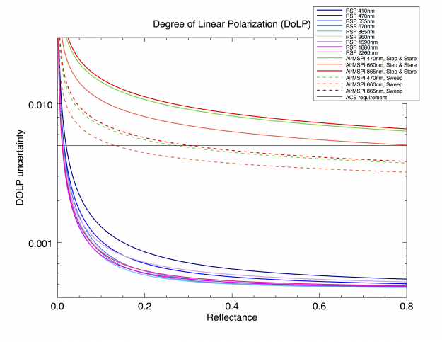 The figure on the right expresses uncertainty assessments for the Degree of Linear Polarization (DoLP) for the AirMSPI (red, green) and RSP (blue, purple) instruments as a function of scene reflectance. PACS was not included because a model for that instrument's uncertainty has yet to be provided. The RSP uncertainty model is also sensitive to scene DoLP and the polarization angle, these were chosen to be 0.3 and 45˚, respectively, for this figure. The solid black line is the ACE polarimetric accuracy requirement, which is a scalar value of 0.005 (0.5%). Solid AirMSPI lines refer to uncertainty for the "Step and Stare" mode, for which data are gridded to a spatial resolution of 10m. Dashed AirMSPI lines are for the "Sweep" mode, gridded to a spatial resolution of 25m. Differences between the two are associated with reduction in noise due to spatial averaging, which is relevant because noise is the dominant source of uncertainty. Level 1 matchups, where AirMSPI data are spatially averaged to RSP resolution, have lower uncertainties (roughly 0.002) where calibration is the largest source of uncertainty).
AirMSPI
The analytical formulation of AirMSPI Reflectance and Degree of Linear Polarization uncertainties are functions of reflectance, as described here. A simulation of these uncertainties as a function of scene reflectance are shown above. The largest contribution to uncertainty is noise, which can be reduced by spatial averaging. Since they are gridded to different spatial resolutions, the "step and stare" and "continuous sweep" are represented individually. Only the coarser spatial resolution "continuous sweep" mode meets ACE requirements for reflectances above about 0.3. DoLP uncertainty can be further reduced by coarser spatial averaging, until systematic (ie calibration) becomes the largest contribution to uncertainty.
Note that this figure represents AirMSPI uncertainty for PODEX data (version 3). SEAC4RS data were calibrated with more sophisticated techniques (version 4). Since noise is the largest source of uncertainty, differences should be minimal unless additional spatial averaging is performed.
A detailed AirMSPI uncertainty description can be found here
PACS
No information is available yet for the PACS instrument.
RSP
The analytical formulation of RSP Reflectance and Degree of Linear Polarization (DoLP) uncertainties are functions of both reflectance and DoLP, as described here. DoLP uncertainty is also minimally sensitive to the polarization angle. A simulation of these uncertainties as a function of scene reflectance are shown at left. ACE requirements are met for reflectances above about 0.025.
A detailed derivation and description of RSP uncertainty can be found here. A summary by K. Knobelspiesse is here.
Reference
Knobelspiesse, K., B. Cairns, M. Mishchenko, J. Chowdhary, K. Tsigaridis, B. van Diedenhoven, W. Martin, M. Ottaviani, and M. Alexandrov, 2012: Analysis of fine-mode aerosol retrieval capabilities by different passive remote sensing instrument designs, Opt. Express, 20, 21457-21484, doi:10.1364/OE.20.021457.